 File image courtesy AFP. |
The system will be used for all types of emergencies listed in the UK's National Risk Register but the project's focus is on flood scenarios. Flooding in summer 2007 cost the UK an estimated Pounds 3 billion, with more than 55,000 homes and businesses inundated and hundreds of thousands of homes losing power or water.
The 'Integrating Space Assets for UK Civil Resilience' project is part of ESA's Integrated Applications Promotion (IAP) programme, which develops value-added services by integrating space assets such as Earth observation, satellite communications and satellite navigation.
The Technology Strategy Board, which is charged with encouraging technology-driven innovation in the UK, provided the catalyst for the project by sponsoring pre-feasibility activities to establish the usefulness of the system.
Working in partnership with the UK Space Agency, the Technology Strategy Board also played an important role in bringing together the diverse project partners from UK industry and is managing the UK's subscription to ESA's satellite telecommunications, navigation and integrated applications programmes.
The UK Space Agency is taking a close interest in the project, having made integrated applications of space assets a national priority. This policy has born fruit for "UK PLC" with the new ESA centre opened at Harwell, Oxfordshire, home of ESA's IAP activities in the UK, and also of the International Space Innovation Centre.
"The IAP is intended to engage directly with users who are not necessarily familiar with the benefits of space systems; our project definitely follows that lead," says Adina Gillespie of DMCii. "We are working with a very large and varied user community including the Civil Contingencies Secretariat of the UK Cabinet Office, numerous Government Departments and agencies, and regional and local authorities."
Having assessed user requirements, the next step will be to design an integrated, easily-operable system, adds Gillespie: "It will be a bespoke tool to include in the tool-kit available to emergency responders and decision makers. It can't be too complicated - in the midst of a disaster there will be no time for picking up new skills such as interpreting satellite imagery."
The system's final shape will be determined based on the user requirements, but it will give responders strong situational awareness using various services in combination, such as:
+ Rapid mapping of affected areas using satellite imagery.
+ Bolstering resilience of communication networks using satellite communications.
+ Enhancing traffic management for evacuations and other activities.
+ Coordinating intelligence for asset management, with everything from ambulances and trucks to flood barriers tagged with GPS.
In March 2011 the government will carry out a National Flood Event exercise to test national flood preparedness. It is being coordinated from the national 'COBRA' level down to local authorities. In an exciting opportunity, the project team has been invited to observe the event then debrief the exercise 'players' outlining how existing space assets could have been used during the exercise.
"Flooding is around the top of the disaster list in terms of impact and frequency - it affects everything," explains Gillespie. "Imagine the worst case scenario and then add water."
The project is being run by a consortium of five organisations: DMCii takes the lead role, with Infoterra Ltd supporting the Earth observation components, Avanti Communications taking the satellite communications role, Nottingham Scientific Ltd working on satellite navigation and the British Geological Survey providing additional expertise on geohazards.
The project will run for approximately 14 months, after which a follow-up demonstration phase is envisaged.
 del.icio.us del.icio.us |
 Digg Digg |
 Reddit Reddit |
 YahooMyWeb YahooMyWeb |
 Google Google |
|
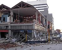 Christchurch New Zealand's most costly disaster: PM
| The content herein, unless otherwise known to be public domain, are Copyright 1995-2010 - SpaceDaily. AFP and UPI Wire Stories are copyright Agence France-Presse and United Press International. ESA Portal Reports are copyright European Space Agency. All NASA sourced material is public domain. Additional copyrights may apply in whole or part to other bona fide parties. Advertising does not imply endorsement,agreement or approval of any opinions, statements or information provided by SpaceDaily on any Web page published or hosted by SpaceDaily. Privacy Statement |