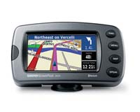
The Garmin Street Pilot 2820.
The Garmin Street Pilot 2820. |
"The StreetPilot series is recognized for incorporating features that make customers' lives easier," said Gary Kelley, vice president of marketing.
"Bluetooth capability is yet another example of our commitment to providing customers with navigation devices with more flexibility and integrated technologies than any other manufacturer."
The Bluetooth wireless technology makes it possible for automotive and motorcycle consumers to take advantage of hands-free calling with a full user interface.
Customers may retrieve and dial numbers using their phone's contact list or from the phone's call history log. A user can also make calls from the StreetPilot 2820's huge points of interest database that includes hotels, restaurants, stores, and much more.
In addition, the Bluetooth connectivity also gives motorcyclists the ability to receive and place phone calls as well as receive navigation audio prompts wirelessly to Bluetooth enabled headsets or helmets.
Real-time traffic is available as an option through either an FM RDS-TMC (Traffic Message Channel) traffic receiver or XM NavTraffic (U.S. only) receiver. When the optional traffic service is activated, the StreetPilot 2820 calculates routes that navigate around traffic.
Accidents, road construction, or other incidents affecting traffic are graphically represented as icons on the navigation map. Information relating to a traffic incident is also available including the precise location, lanes affected, and the predicted duration. Customers selecting the XM NavTraffic receiver can also access XM's weather forecasts, audio, and stock reports.
The StreetPilot 2820 also allows customers to load customized points of interest (POIs) such as safety cameras and school zones.
A proximity alert option can warn the driver of upcoming custom POIs, and will help reinforce the importance of traveling at appropriate and legal speeds. The customized POIs are in addition to a huge pre-loaded POI database with popular attractions such as hotels, restaurants, gas stations, and attractions. The map data is provided by NAVTEQ -- a world leader in premium-quality mapping.
For longer road trips, the StreetPilot 2820's MP3 player and audiobook player will help pass the time. The MP3 player allows users to browse music by artist, album, song, or genre. Audio books may be obtained from audible.com, which features more than 70,000 hours of audio programs from more than 200 content partners.
The StreetPilot 2820 is waterproof (IEC 529 IPX7 standards) and has a durable touchscreen that is optimized for outdoor use. In addition, the unit relies upon solid state memory, which is the industry's optimal solution for devices that are exposed to fluctuating cold, heat, shock, and vibration. This memory also makes it possible for Garmin's automotive products to display and redraw maps faster, so customers see no lag time.
The StreetPilot 2820 is expected to be available in June for estimated retail price of $1,099. The unit ships standard with pre-loaded maps of either Europe or North America, a 12-volt power cable with external speaker, alphanumeric remote control, PC/USB interface cable, AC power adapter, beanbag mount, dash mount, external microphone, City Navigator DVD, owner's manual, and quick reference setup guide.
Related Links
 Redmond WA (SPX) May 05, 2006
| The content herein, unless otherwise known to be public domain, are Copyright 1995-2006 - SpaceDaily.AFP and UPI Wire Stories are copyright Agence France-Presse and United Press International. ESA PortalReports are copyright European Space Agency. All NASA sourced material is public domain. Additionalcopyrights may apply in whole or part to other bona fide parties. Advertising does not imply endorsement,agreement or approval of any opinions, statements or information provided by SpaceDaily on any Web page published or hosted by SpaceDaily. Privacy Statement |