 File image. |
GeoCue Corporation, which is the parent company of QCoherent Software LLC, offers the LP360 product line, a LiDAR software extension for the Esri ArcGIS Environment.
With the integration of LizardTech's MG4 DSDK, LP360 customers will have the ability to efficiently input and decode LIDAR data that has been compressed using LizardTech's LiDAR Compressor software.
Lewis Graham, president and chief technical officer at GeoCue, believes this integration will be very well received by users of LP360 software.
"Our customers have asked for tools to input, decode, and view compressed LiDAR point clouds, and with the integration of LizardTech's MG4 DSDK, they can do that easily and efficiently."
"We're pleased with this integration as it confirms LizardTech's commitment to our customers in enabling them to use our product in as many other applications as possible," said Jon Skiffington, director of product management.
"Now LP360 users will be able to handle compressed LiDAR datasets in ArcGIS."
 del.icio.us del.icio.us |
 Digg Digg |
 Reddit Reddit |
 YahooMyWeb YahooMyWeb |
 Google Google |
|
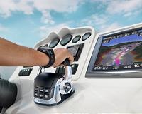 Garmin And Volvo Penta Form Strategic Alliance
| The content herein, unless otherwise known to be public domain, are Copyright 1995-2010 - SpaceDaily. AFP and UPI Wire Stories are copyright Agence France-Presse and United Press International. ESA Portal Reports are copyright European Space Agency. All NASA sourced material is public domain. Additional copyrights may apply in whole or part to other bona fide parties. Advertising does not imply endorsement,agreement or approval of any opinions, statements or information provided by SpaceDaily on any Web page published or hosted by SpaceDaily. Privacy Statement |