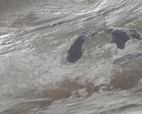
 NASA's Earth Observing System Data Information System (EOSDIS) manages the constant streams of observational data from the agency's Earth-observing satellites. This composite image, compiled from data captured on July 11, 2005, by the Moderate-Resolution Imaging Spectroradiometer (MODIS). MODIS data - from instruments on satellites Terra and Aqua - represents just a fraction of the Earth observations that EOSDIS manages on a daily basis. The organization, which supplies data to more than 1 million users worldwide, was recently recognized by the American Customer Satisfaction Index (ACSI) for a high customer satisfaction score. Credit: MODIS/NASA Earth Observatory. For a larger version of this image please go here. |
EOSDIS is the network of Earth science data centers that process, store, and make available the trove of data from NASA's past and current Earth-observing satellites. For the past seven years, EOSDIS management has collected thousands of responses from users of its system as a way to both gather metrics and improve on its delivery.
EOSDIS works with the American Customer Satisfaction Index (ACSI) to systematically track its standing and progress through the eyes of its users.
In the recently released ACSI ratings for 2010, EOSDIS achieved a customer satisfaction score well above the standard for government agencies and even higher scores in several key categories. EOSDIS scored a 77 on a scale of 0 to 100, while the government benchmark is 65. EOSDIS has maintained scores in the high 70s over the past several years.
"This accomplishment is particularly noteworthy given its consistency, even though customer expectations rose during that period," said Ron Oberbillig, Chief Operating Officer of the Federal Consulting Group, executive agent within the federal government that works with ACSI on behalf of all agencies. Oberbillig particularly lauded EOSDIS for scores in the upper eighties when customers were asked about their likelihood to use the data centers in the future and willingness to recommend the data centers to colleagues.
"We use the ACSI surveys as a way to measure our performance, but also as a way to keep improving on what we do" said Jeanne Behnke, EOSDIS Deputy Project Manager for Operations at NASA Goddard.
Behind the Scenes
Satellites have ushered in a new era of Earth science in the past few decades. A constantly orbiting fleet of NASA satellites keeps its sensors trained on our blue planet - capturing the intricacies of its atmosphere, the seasonal cycles of plant growth and sea ice, and the patterns in ocean circulation and temperature.
EOSDIS manages constant streams of data for scientists to dissect and discover new knowledge about how our planet's dynamic systems work and interact with one another. But before any scientific investigation can begin, the raw data itself must be received, stored, processed and made available.
It's a process that often occurs behind the scenes but ultimately enables all the NASA-related studies of Earth and its climate. EOSDIS manages this flow of information - from satellites in space to data processing facilities to a scientist's desktop - with a network of 12 Earth science data centers in the U.S.
These Earth science data centers are located at NASA centers or partner institutions and specialize in specific types of datasets, such as snow and ice, atmospheric or ocean data.
NASA's Earth Observing System (EOS) was devised to make long-term, comprehensive measurements of Earth's interrelated systems - to capture their fundamental nature and any natural or man-made changes.
In the 1990s, EOS identified 24 key measurements of Earth systems, and EOSDIS manages the gathering and distribution of those measurements from end to end - from command and control of several satellites, to coordination of data gathering through ground stations the world over, to the distribution interface on NASA websites where scientists can download data.
The wide-ranging effort essentially takes a long-term measure of the scope of Earth's land, atmosphere and ocean systems. While EOS is only about 15 years old, these data records will become more valuable as they capture a longer period of time and more natural and man-made variability in the various Earth systems.
That makes the EOSDIS task of not only processing but also archiving all NASA data a vital component to the future of Earth science.
Moving Forward
"Likewise, the annual use of the ACSI survey will become more valuable to EOSDIS over time, as the organization can see how users respond to changes prompted by their comments," EOSDIS outreach manager Carol Boquist said. The ACSI score is certain to remain a key metric for an organization whose goal is to make as much data available in as easy a manner as possible.
"At our core, we are delivering an extensive array of products to a national and international base of scientists, researchers, educators, and the general public," Boquist said. "With new data products always coming online and our users' needs constantly changing, the only way to make sure we're succeeding is to ask."
 del.icio.us del.icio.us |
 Digg Digg |
 Reddit Reddit |
 YahooMyWeb YahooMyWeb |
 Google Google |
|
 A Snowy US Panorama By Satellite
| The content herein, unless otherwise known to be public domain, are Copyright 1995-2010 - SpaceDaily. AFP and UPI Wire Stories are copyright Agence France-Presse and United Press International. ESA Portal Reports are copyright European Space Agency. All NASA sourced material is public domain. Additional copyrights may apply in whole or part to other bona fide parties. Advertising does not imply endorsement,agreement or approval of any opinions, statements or information provided by SpaceDaily on any Web page published or hosted by SpaceDaily. Privacy Statement |