| . |  |
. |
|
|
. |
by Patrick Lynch Boulder CO (SPX) Oct 05, 2011
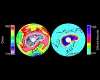
Last month the extent of sea ice covering the Arctic Ocean declined to the second-lowest extent on record. Satellite data from NASA and the NASA-supported National Snow and Ice Data Center (NSIDC) at the University of Colorado in Boulder showed that the summertime sea ice cover narrowly avoided a new record low. The Arctic ice cap grows each winter as the sun sets for several months and shrinks each summer as the sun rises higher in the northern sky. Each year the Arctic sea ice reaches its annual minimum extent in September. It hit a record low in 2007. The near-record ice-melt followed higher-than-average summer temperatures, but without the unusual weather conditions that contributed to the extreme melt of 2007. "Atmospheric and oceanic conditions were not as conducive to ice loss this year, but the melt still neared 2007 levels," said NSIDC scientist Walt Meier. "This probably reflects loss of multiyear ice in the Beaufort and Chukchi seas as well as other factors that are making the ice more vulnerable." Joey Comiso, senior scientist at NASA's Goddard Space Flight Center in Greenbelt, Md., said the continued low minimum sea ice levels fits into the large-scale decline pattern that scientists have watched unfold over the past three decades. "The sea ice is not only declining, the pace of the decline is becoming more drastic," Comiso said. "The older, thicker ice is declining faster than the rest, making for a more vulnerable perennial ice cover." While the sea ice extent did not dip below the 2007 record, the sea ice area as measured by the microwave radiometer on NASA's Aqua satellite did drop slightly lower than 2007 levels for about 10 days in early September, Comiso said. Sea ice "area" differs from extent in that it equals the actual surface area covered by ice, while extent includes any area where ice covers at least 15 percent of the ocean. Arctic sea ice extent on Sept. 9, the lowest point this year, was 4.33 million square kilometers (1.67 million square miles). Averaged over the month of September, ice extent was 4.61 million square kilometers (1.78 million square miles). This places 2011 as the second lowest ice extent both for the daily minimum extent and the monthly average. Ice extent was 2.43 million square kilometers (938,000 square miles) below the 1979 to 2000 average. This summer's low ice extent continued the downward trend seen over the last 30 years, which scientists attribute largely to warming temperatures caused by climate change. Data show that Arctic sea ice has been declining both in extent and thickness. Since 1979, September Arctic sea ice extent has declined by 12 percent per decade. "The oldest and thickest ice in the Arctic continues to decline, especially in the Beaufort Sea and the Canada Basin," NSIDC scientist Julienne Stroeve said. "This appears to be an important driver for the low sea ice conditions over the past few summers." Climate models have suggested that the Arctic could lose almost all of its summer ice cover by 2100, but in recent years, ice extent has declined faster than the models predicted. NASA monitors and studies changing sea ice conditions in both the Arctic and Antarctic with a variety of spaceborne and airborne research capabilities. This month NASA resumes Operation IceBridge, a multi-year series of flights over sea ice and ice sheets at both poles. This fall's campaign will be based out of Punta Arenas, Chile, and make flights over Antarctica. NASA also continues work toward launching ICESat-2 in 2016, which will continue its predecessor's crucial laser altimetry observations of ice cover from space.
National Snow and Ice Data Center (NSIDC) Earth Observation News - Suppiliers, Technology and Application
|
. |
|
| The content herein, unless otherwise known to be public domain, are Copyright 1995-2011 - Space Media Network. AFP and UPI Wire Stories are copyright Agence France-Presse and United Press International. ESA Portal Reports are copyright European Space Agency. All NASA sourced material is public domain. Additional copyrights may apply in whole or part to other bona fide parties. Advertising does not imply endorsement,agreement or approval of any opinions, statements or information provided by Space Media Network on any Web page published or hosted by Space Media Network. Privacy Statement |

 del.icio.us
 Digg
Digg Reddit
 Google