| . |  |
. |
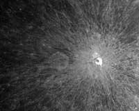
Beijing (XNA) Dec 12, 2007 The charge-coupled device (CCD) camera on Chang'e-1, China's first lunar orbiter, has started imaging probes on the dark side of the moon and captured photos of parts of this region, the China National Space Administration (CNSA) announced Tuesday. The CNSA said that the orbiter is operating normally in terms of flying, probing, land control and communication, as well as data transmitting and processing. The CNSA released the first picture of the moon captured by Chang'e-1 on Nov. 26, marking the full success of the lunar probe project. Chang'e-1, named after a mythical Chinese goddess who, according to legend, flew to the moon, blasted off on a Long March 3A carrier rocket at 6:05 p.m. on Oct. 24 from the Xichang Satellite Launch Center in the southwestern Sichuan Province. The 2,350-kg satellite carries eight probing facilities with a range of instruments. These include a three-dimensional camera and an interferometer (a set of two or more telescopes that combine their signals to improve resolution), an imager and gamma/x-ray spectrometer, a laser altimeter, a microwave detector, a high-energy solar particle detector and a low-energy ion detector. The mission has four objectives: a three-dimensional survey of the lunar surface; an analysis of the abundance and distribution of elements on the lunar surface; an investigation of the characteristics of lunar regolith (loose, fragmented surface material) and the powdery soil layer on the surface, and an exploration of the conditions between Earth and the moon.
Source: Xinhua News Agency Community Email This Article Comment On This Article Related Links The Chinese Space Program - News, Policy and Technology China News from SinoDaily.com
 Beijing (XNA) Dec 07, 2007
A leading engineer for China's indigenous satellite navigation system said the new system would be used in guiding traffic and monitoring sports venues during the Beijing Olympics in summer 2008. Ran Chengqi, deputy director of China Satellite Navigation Engineering Center, said the Compass Navigation Satellite System, which consists of five positioning satellites orbiting the Earth, will help alleviate traffic problems during the Olympics by providing detailed positioning information to individual drivers. |
|
| The content herein, unless otherwise known to be public domain, are Copyright 1995-2006 - SpaceDaily.AFP and UPI Wire Stories are copyright Agence France-Presse and United Press International. ESA PortalReports are copyright European Space Agency. All NASA sourced material is public domain. Additionalcopyrights may apply in whole or part to other bona fide parties. Advertising does not imply endorsement,agreement or approval of any opinions, statements or information provided by SpaceDaily on any Web page published or hosted by SpaceDaily. Privacy Statement |