| . |  |
. |
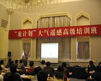
Paris, France (SPX) Oct 23, 2006 Over 50 doctoral level Chinese scientists from 30 institutes have gathered at the prestigious Peking University in Beijing in the People's Republic of China to attend a six-day advanced training course devoted to atmosphere monitoring over China using ESA remote sensing instruments. ESA and the National Remote Sensing Centre of China (NRSCC) are sponsoring the course under the framework of the Dragon Programme - a wide-ranging research initiative designed to encourage increased exploitation of ESA remote sensing satellite data within China as well as stimulate increased scientific co-operation in the field of Earth Observation (EO) science and applications between China and Europe. "International cooperation and coordination are needed to sustain Earth Observation systems. Access to and use of data and products obtained from satellites and ground-based observations require transfer of know-how to the young generation of scientists emerging in many countries and worrying about the endangered Earth and its future," Prof. Paul Simon from the Belgian Institute for Space Aeronomy (IASB) said. "Advanced training courses such as the Dragon ones are an important tool to adequately address this challenge at the beginning of the 21st century." "With the Dragon training, European atmospheric scientists and young Chinese researchers have an excellent opportunity to exchange their scientific concepts, share experiences and establish new cooperation while making extensive use of satellite data," Prof. Hendrik Elbern of the Rhenish Institute of Environmental Research at the University of Cologne said. The course, being held from 16 to 21 October, is aimed at teaching the students about the different atmospheric instruments aboard ESA's Envisat and ERS-2 satellites and training the students to apply tools and use the complementary atmospheric data sets for applications like air pollution monitoring, ozone trend monitoring and stratospheric and mesospheric research. "The Advanced training course in atmosphere remote sensing of the ESA-MOST Dragon Programme is an excellent chance for me to get access to the latest information, to acquire new knowledge and to master advantageous tools for atmosphere remote sensing," HU Zhowei, a student from Capital Normal University, said. Space-based sensors are a very good way to carry out effective global and regional monitoring of the atmosphere and are especially useful tools for analysing trends and seasonal variations in atmospheric gases. The Global Ozone Monitoring by Occultation of Stars (GOMOS), Michelson Interferometer for Passive Atmospheric Sounding (MIPAS) and the Scanning Imaging Absorption Spectrometer for Atmospheric Chartography (SCIAMACHY) instruments aboard Envisat have significantly enriched the scope of observational capabilities by making use of a variety of novel measurement techniques and enhanced spectral coverage. These instruments also represent a continuation of the Global Ozone Monitoring Experiment (GOME) instrument aboard ERS-2. Together, these data give users unprecedented insight into the atmosphere's chemical and physical processes. Five key European scientists, who have been involved in defining these instruments, algorithms and applications development, will present information on retrieval techniques, validation, models and data assimilation. This year's course is the third advanced training course in China since 2004. In October 2004, an advanced training course in ocean remote sensing was successfully held at the Ocean University of China, Qingdao. In October 2005, a six-day training course in land remote sensing was organised at the Capital Normal University in Beijing, which was attended by over 100 Chinese scientists. By the end of this course, nearly 250 Chinese scientists will have received training on ESA instruments and applications.
Satellite instruments in spotlight SCIAMACHY can identify multiple trace gases including the pollutant nitrogen dioxide created artificially by vehicle exhausts, fossil fuel burning and heavy industry. SCIAMACHY results tallied with previous results gathered by GOME showed a steady increase in nitrogen dioxide levels in industrialised eastern China. GOMOS is an ESA instrument aimed at ozone monitoring by measuring occultation of stars. It provides altitude-resolved global ozone mapping and trend monitoring with very high accuracy, as needed for the understanding of ozone chemistry and for model validation.
MIPAS is a Michelson interferometer that detects the Earth's limb emission in the mid-infrared. MIPAS provides accurate vertical profiles of atmospheric temperature and a number of key trace gases and covers a height range from the upper troposphere to the lower mesosphere.
Dragon Programme highlights There are currently 16 Dragon projects including agricultural and forest monitoring, water resource assessment, atmospheric chemistry, terrain measurement, the ocean environment and climate change, among others. The joint Sino-European teams are led by Chinese and European lead investigators. Earth-observing satellites are particularly useful for tackling and monitoring environmental phenomena in China, the third largest country in the world, because of the country's sheer size and various types of terrain, which range from Himalayan peaks to tropical lowlands. Related Links Read More About the Chinese Space Program The Air We Breathe at TerraDaily.com  Beijing (XNA) Oct 23, 2006
China is to launch its second geosynchronous meteorological satellite on the "Long March 3" launch vehicle, from Xichang Satellite Launch Centre at the end of this year. The new geosynchronous meteorological satellite, Fengyun-2E (FY-2E), has passed through the examination and approval of Chinese experts after its assembly, according to a report by the People's Daily. |
|
| The content herein, unless otherwise known to be public domain, are Copyright 1995-2006 - SpaceDaily.AFP and UPI Wire Stories are copyright Agence France-Presse and United Press International. ESA PortalReports are copyright European Space Agency. All NASA sourced material is public domain. Additionalcopyrights may apply in whole or part to other bona fide parties. Advertising does not imply endorsement,agreement or approval of any opinions, statements or information provided by SpaceDaily on any Web page published or hosted by SpaceDaily. Privacy Statement |