| . |  |
. |
Denver CO (SPX) Nov 12, 2010 From monitoring vanishing glaciers to the accounting of forestry, hydropower and mining assets as steps to boost sustainable development here on Earth, the power of satellite remote sensing plays an increasingly vital role. These topics and others are highlighted in the Fall 2010 issue of the quarterly print and online publication - Imaging Notes magazine. "Secure World Foundation in 2009 established a partnership with Imaging Notes magazine," said Dr. Ray Williamson, SWF's Executive Director. "A key focus of our organization centers on strengthening or developing the policies and institutions that improve the utility of space technologies in support of human and environmental security needs. We are pleased to be a partner with Imaging Notes to help support our objectives."
Community action Imaging Notes and Secure World Foundation have taken a lead role in gauging the expanding use of CRS - a new field that combines remote sensing with citizen science, social networks, and crowd-sourcing to enhance the data obtained from traditional sources. It includes the collection, calibration, analysis, communication, or application of remotely sensed information by these community means. Other Imaging Notes articles delve into satellite camera systems that feed imagery to such users as Google Earth and the Weather Channel and information sharing incongruities in the intelligence community.
Paradox of choice Asks Myrna James Yoo, publisher of Imaging Notes: "Too much data...dare I say it?" She notes that an issue rising to the surface in the past few years is the question of having too much data - so much so that processing it and using it are major challenges.
Share This Article With Planet Earth
Related Links Imaging Notes Earth Observation News - Suppiliers, Technology and Application
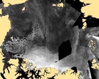 NASA Study Quantifies Role Of Melt In Loss Of Old Arctic Sea Ice
Greenbelt MD (SPX) Nov 10, 2010 Since the start of the satellite record in 1979, scientists have observed the continued disappearance of older "multiyear" sea ice that survives more than one summer melt season. Some scientists suspected that this loss was due entirely to wind pushing the ice out of the Arctic Basin - a process that scientists refer to as "export." In this study, Ron Kwok and Glenn Cunningham at NASA's Je ... read more |
|
| The content herein, unless otherwise known to be public domain, are Copyright 1995-2010 - SpaceDaily. AFP and UPI Wire Stories are copyright Agence France-Presse and United Press International. ESA Portal Reports are copyright European Space Agency. All NASA sourced material is public domain. Additional copyrights may apply in whole or part to other bona fide parties. Advertising does not imply endorsement,agreement or approval of any opinions, statements or information provided by SpaceDaily on any Web page published or hosted by SpaceDaily. Privacy Statement |


 del.icio.us
 Digg
Digg Reddit
 YahooMyWeb
 Google