| . |  |
. |
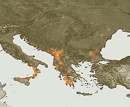
Paris, France (ESA) Aug 28, 2007 Hot spots across Southeastern Europe from 21 to 26 August have been detected with instruments aboard ESA satellites, which have been continuously surveying fires burning across the Earth's surface for a decade. Working like thermometers in the sky, the Along Track Scanning Radiometer (ATSR) on ESA's ERS-2 satellite and the Advanced Along Track Scanning Radiometer (AATSR) on ESA's Envisat satellite measure thermal infrared radiation to take the temperature of Earth's land surfaces. Temperatures exceeding 312K (38.85C) are classed as burning fires by AATSR, which is capable of detecting fires as small as gas flares from industrial sites because of their high temperature. Worldwide fire maps based on this data are available to users online in near-real time through ESA's ATSR World Fire Atlas (WFA). Smoke from some of the fires included in the WFA fire map was detected during the same period by Envisat's Medium Resolution Imaging Spectrometer (MERIS) optical instrument. While working in Full Resolution mode to provide a spatial resolution of 300 metres, MERIS captured smoke plumes arising from fires raging across Greece's southern Peloponnese peninsula, where fires have claimed the lives of at least 60 people since they began four days ago. These images are available on ESA's MIRAVI website, which gives access to Envisat's most recently acquired images. MIRAVI, short for MERIS Images RApid VIsualisation, tracks Envisat - the world's largest Earth Observation satellite - around the globe, generates images from the raw data collected by MERIS and provides them online within two hours. MIRAVI is free and requires no registration. MERIS is also being utilised in combination with other satellite sensors for the Risk-EOS initiative, a series of operational services for fire and flood risk management. Risk-EOS is part of the Services Element of 'Global Monitoring for Environment and Security' (GMES), an initiative supported jointly by ESA and the European Commission. GMES is intended to establish an independent European capability for worldwide environmental monitoring on an operational basis. Community Email This Article Comment On This Article Related Links Earth Observation News - Suppiliers, Technology and Application
 Beijing, China (Xinhua) Aug 16, 2007
China has developed its Beidou satellite monitoring system for dangerous chemicals transportation, the Beijing Times reported here Monday. The system, which has passed experts review, provides all-day data of dangerous chemicals transportation to Beidou navigation satellite and gives corresponding operational order, the paper said. Scores of sensors, equipped on every vehicle transporting dangerous chemicals, collect data and information of the vehicle as well as road condition. |
|
| The content herein, unless otherwise known to be public domain, are Copyright 1995-2006 - SpaceDaily.AFP and UPI Wire Stories are copyright Agence France-Presse and United Press International. ESA PortalReports are copyright European Space Agency. All NASA sourced material is public domain. Additionalcopyrights may apply in whole or part to other bona fide parties. Advertising does not imply endorsement,agreement or approval of any opinions, statements or information provided by SpaceDaily on any Web page published or hosted by SpaceDaily. Privacy Statement |