| . |  |
. |
El Segundo CA (SPX) Aug 31, 2010 Boeing has announced that the first of 12 Global Positioning System (GPS) IIF satellites the company is building for the U.S. Air Force has entered service. GPS IIF-1 is the newest member of the active 31-satellite GPS constellation, which provides accurate navigation, positioning and timing information to more than 1 billion military and civilian users around the world. GPS IIF satellites offer new and enhanced capabilities, including a jam-resistant military signal, greater accuracy through improved atomic clock technology, and a protected civilian L5 signal to aid commercial aviation and safety-of-life applications. According to Air Force officials, on-orbit testing shows that the L5 signal meets all requirements. Based on program plans, the signal will remain in development status, broadcasting test data until initial operational capability is declared. The Air Force will send a message about this to GPS users worldwide. "Putting the first next-generation GPS IIF satellite into operation is a significant step forward for the Air Force and the millions of warfighters and civilians who depend on this vital system," said Air Force Col. Bernard Gruber, commander, GPS Wing. "Now that IIF-1 is operational, military and commercial receivers around the world can begin using the satellite's improved signals to more accurately determine their position." Launched on May 27, 2010, GPS IIF-1 has undergone three months of comprehensive on-orbit testing to validate its operations with the ground control system, other GPS satellites and a wide range of military and commercial GPS ground receivers. The satellite's testing regimen was longer and more rigorous than usual because it is the first of the series. A Boeing space vehicle operations team based in Colorado helped the GPS Wing monitor and evaluate test results as GPS IIF-1 went through many of its first on-orbit operations. With testing complete, the GPS Wing has officially transferred Satellite Control Authority to the Air Force 50th Space Wing and the 2nd Space Operations Squadron, which will operate the satellite on its mission. "Boeing has built 40 of the 61 GPS satellites launched since 1978, and GPS IIF is a great addition to that long legacy," said Craig Cooning, vice president and general manager of Boeing Space and Intelligence Systems. "These satellites make a difference by adding new levels of power and precision to GPS services. The IIF series will be the backbone of the constellation for the next 12 to 15 years." Boeing is producing the next 11 GPS IIF satellites using an innovative pulse-line manufacturing approach adapted from the company's aircraft and helicopter assembly lines. The line enables faster, more efficient development of several satellites at once. The company also developed the current GPS ground control infrastructure, called the Operational Control Segment (OCS), which has supported an expanding set of GPS services and capabilities since 2007.
Share This Article With Planet Earth
Related Links Boeing Defense, Space and Security GPS Applications, Technology and Suppliers
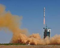 China Launches New Mapping Satellite
Jiuquan, Gansu (XNA) Aug 26, 2010 China successfully launched a mapping satellite, "Mapping Satellite - I," from the northwestern Jiuquan Satellite Launch Center at 3:10 p.m. (Beijing time) Tuesday. The satellite, which was launched on a Long March 2-D carrier rocket, had entered into the preset orbit, according to the center. The satellite, developed by a company under the China Aerospace Science and Technology Corp ... read more |
|
| The content herein, unless otherwise known to be public domain, are Copyright 1995-2010 - SpaceDaily. AFP and UPI Wire Stories are copyright Agence France-Presse and United Press International. ESA Portal Reports are copyright European Space Agency. All NASA sourced material is public domain. Additional copyrights may apply in whole or part to other bona fide parties. Advertising does not imply endorsement,agreement or approval of any opinions, statements or information provided by SpaceDaily on any Web page published or hosted by SpaceDaily. Privacy Statement |


 del.icio.us
 Digg
Digg Reddit
 YahooMyWeb
 Google