| . |  |
. |
Greenbelt MD (SPX) May 25, 2011 The Geostationary Operational Environmental Satellite called GOES-13 provides forecasters with continuous visible and infrared imagery of weather systems across the U.S. and a new movie from the NASA GOES project gives a close up of the storm the created the monster tornado that devastated Joplin, Missouri yesterday. An animation of imagery from the GOES-13 satellite was created from images taken before, during and after the time the massive tornado touched down in Joplin, Missouri on Sunday, May 22. The nominal time of the tornado was 5:30 p.m. CDT, which is 2230 UTC. Meteorologist Dennis Chesters of the NASA GOES Project at NASA's Goddard Space Flight Center in Greenbelt Md. created the animation from GOES imagery to show the progression of the storm system. The animation of visible imagery begins on May 22 at 17:44 UTC (12:44 p.m. CDT). In the video, Chesters identified the location of Joplin so viewers can see the line of thunderstorms that generated the tornado as the animation continues. "The convection above a tornado normally penetrates to the cloud tops and makes visible ripples about 10 minutes after the tornado hits the ground," Chesters said. The animation ends on May 23 at 00:15 UTC (7:15 p.m. CDT, May 22, 2011). According to reports from the Joplin Globe on-line, the tornado was one half-mile wide when it struck Joplin and expanded to three-quarters of a mile wide before dissipating. On May 23, the death toll reached 89 people. The GOES series of satellites are managed and operated by the National Oceanic and Atmospheric Administration (NOAA). NASA's GOES Project, located at NASA Goddard, procures and manages the development and launch of the GOES series of satellites for NOAA on a cost-reimbursable basis. NASA's GOES Project also creates some of the GOES satellite images and GOES satellite imagery animations. NOAA manages the operational environmental satellite program and establishes requirements, provides all funding and distributes environmental satellite data for the United States.
Share This Article With Planet Earth
Related Links Goddard Space Flight Center Earth Observation News - Suppiliers, Technology and Application
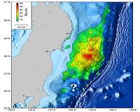 NASA/University Japan Quake Study Yields Surprises
Pasadena CA (SPX) May 23, 2011 When the magnitude 9.0 Tohoku-Oki earthquake and resulting tsunami struck off the northeast coast of Japan on March 11, they caused widespread destruction and death. Using observations from a dense regional geodetic network (allowing measurements of earth movement to be gathered from GPS satellite data), globally distributed broadband seismographic networks, and open-ocean tsunami data, research ... read more |
|
| The content herein, unless otherwise known to be public domain, are Copyright 1995-2010 - SpaceDaily. AFP and UPI Wire Stories are copyright Agence France-Presse and United Press International. ESA Portal Reports are copyright European Space Agency. All NASA sourced material is public domain. Additional copyrights may apply in whole or part to other bona fide parties. Advertising does not imply endorsement,agreement or approval of any opinions, statements or information provided by SpaceDaily on any Web page published or hosted by SpaceDaily. Privacy Statement |


 del.icio.us
 Digg
Digg Reddit
 YahooMyWeb
 Google