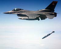
The demonstration, in which an inert weapon was delivered within two meters of the moving target, required no new radios or hardware alterations to the aircraft.
The demonstration, in which an inert weapon was delivered within two meters of the moving target, required no new radios or hardware alterations to the aircraft. |
The demonstration, in which an inert weapon was delivered within two meters of the moving target, required no new radios or hardware alterations to the aircraft.
The position of the target - a radio-controlled panel-side truck - was continuously tracked by the Super Hornet's on-board sensor and target updates were provided by the aircraft's communication system to the JDAM GPS-guided weapon equipped with Harris' new network-capable weapon data link.
The two-way link also demonstrated the ability of the weapon data link to transmit real-time weapon status back to the host F/A-18 aircraft during the JDAM's free fall.
In developing this new approach, Harris combined the advanced engineering skills of its Government Communications Systems Division (GCSD) with the reliable, secure communications data link afforded by the combat-proven Harris Falcon(r) II radio from its RF Communications Division and Improved Data Modem technology from Innovative Concepts, Inc. to create data linkage that is mounted onboard the JDAM.
"JDAM is a high-profile munition, and its ability to carry out highly accurate strikes is playing a significant role in how our armed forces conduct their operations," said Dan Pearson, president of the Department of Defense business unit of Harris GCSD.
Harris also is providing Anti-Jam Global Positioning System (AJ GPS) modules to Boeing for the JDAM, which is a low-cost tail kit that converts existing free-fall bombs into highly accurate, "smart" weapons. AJ GPS technology enhances the munition's resistance to both intentional and unintentional RF interference of the GPS satellite signal.
Harris GCSD conducts advanced research studies, develops prototypes, and produces and supports state-of-the-art, assured communications solutions and information systems that solve the mission-critical challenges of its military and government customers, while serving as the technology base for the company's diverse commercial businesses.
Related Links
 Shanghai (AFP) Sep 22, 2005
| The content herein, unless otherwise known to be public domain, are Copyright 1995-2006 - SpaceDaily.AFP and UPI Wire Stories are copyright Agence France-Presse and United Press International. ESA PortalReports are copyright European Space Agency. All NASA sourced material is public domain. Additionalcopyrights may apply in whole or part to other bona fide parties. Advertising does not imply endorsement,agreement or approval of any opinions, statements or information provided by SpaceDaily on any Web page published or hosted by SpaceDaily. Privacy Statement |