| . |  |
. |
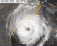
White Plains NY (SPX) Jun 09, 2006 Hurricane season officially began on June 1, and national forecasters predict another active hurricane season for 2006, with an estimated eight to ten hurricanes expected. Of these, they predict four to six will escalate to "major" hurricanes of Category Three strength or higher. ITT Industries continues to engineer critical technologies that enable forecasters to predict and monitor the course of a hurricane, and is currently developing instruments for the next generation of meteorological satellites. "With an increased number of hurricanes affecting the country, it's critical that communities in danger of severe weather be warned as far in advance as possible," said Frank Koester, Vice President and Director of ITT Space Systems Division Commercial and Space Science Programs. "Advance warning, leading to community preparedness and potential evacuation, is the best way to mitigate the effects of natural disasters. Because of this, ITT continues to invest in technology that will improve the timeliness and accuracy of weather forecasts."
Sensing Technology Today There are two types of meteorological satellites: geostationary and polar-orbiting. Geostationary Operational Environmental Satellites (GOES) and Polar Operational Environmental Satellites (POES) carry a suite of instruments, including imagers and sounders developed and produced by ITT that monitor and measure moisture and temperature in weather systems. Although used for different purposes, these satellites work in a similar manner. GOES is a family of satellites and sensors located 22,000 miles above the earth in a pre-set geostationary orbit. GOES provides nearly continual monitoring of the northern hemisphere and is used to track hurricanes and violent weather in that region. POES is a group of satellites and sensors that orbit the earth approximately every 90 minutes. POES instruments provide detailed sounding information that enables forecasters to refine numerical weather prediction models and help determine the direction a hurricane is traveling.
Sensing Technology Tomorrow Compared with today's advanced systems, National Polar-orbiting Operational Environmental Satellites, or NPOESS, will improve even further data provided to weather forecasters by using ITT's Cross-track Infrared Sounder, or CrIS. CrIS, one of the most advanced sounders ever, will track a vertical distribution of temperature, moisture, and pressure in the atmosphere, which will help in both short-term weather predictions and long-term forecasting. NPOESS is scheduled to replace POES in 2011. ITT is also developing the GOES Advanced Baseline Imager, planned for launch around 2012, which will help better track violent weather. This instrument will include the most capable American-built imager ever used on a NOAA weather satellite. Used for a wide range of weather, oceanographic, climate, and environmental applications, the technology will improve upon the current GOES imager by adding more spectral bands, faster imaging, higher spatial resolution, better navigation, and more accurate calibration. Additionally, ITT is developing concepts for the GOES-R Global Lightning Mapper and Hyperspectral Environmental Suite (HES). The Mapper will help detect and locate lightning. This will help forecasters improve the routing of airlines around severe storms which are increasingly viewed as precursors to tornados. HES will be critical in predicting the path and strength of violent weather such as hurricanes, hail storms and tornados. The Coastal Waters Imager, part of HES, will provide high resolution images of algae blooms and river effluents detrimental to commercial fishing and recreation. Since 1965, ITT has been developing sophisticated imaging and sounding instruments that go on board meteorological satellites produced for NOAA to track severe weather patterns and by meteorologists for weather forecasting. Related Links ITT Industries 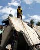 Jakarta (AFP) Jun 14, 2006
Rebuilding Indonesia's quake-hit central Java will cost more than three billion dollars, with the scale of residential destruction rivalling that of the tsunami in Aceh, an official said Tuesday. |
|
| The content herein, unless otherwise known to be public domain, are Copyright 1995-2006 - SpaceDaily.AFP and UPI Wire Stories are copyright Agence France-Presse and United Press International. ESA PortalReports are copyright European Space Agency. All NASA sourced material is public domain. Additionalcopyrights may apply in whole or part to other bona fide parties. Advertising does not imply endorsement,agreement or approval of any opinions, statements or information provided by SpaceDaily on any Web page published or hosted by SpaceDaily. Privacy Statement |