. Military Space News .


.
EARTH OBSERVATION
Landsat 5 Satellite Sees Mississippi River Floodwaters Lingering
by Staff Writers
Greenbelt MD (SPX) Jun 20, 2011

The Landsat 5 satellite Thematic Mapper captured this image on June 11, 2011. In the false-color images, water is navy blue. Depending on land use, land above water is green or burnt orange. The image is rotated, with the left sides facing north. (Credit: NASA Earth Observatory images created by Jesse Allen and Robert Simmon, using Landsat data provided by the United States Geological Survey)

On May 19, 2011, the Mississippi River reached a historic crest at Vicksburg. According to the Advanced Hydrological Prediction Service (AHPS) of the U.S. National Weather Service, the river reached 57.10 feet (17.40 meters) that day. By early June, flooding had receded considerably around Vicksburg, but water remained high.

On June 14, the AHPS reported that the Mississippi River reached 44.88 feet (13.68 meters) at Vicksburg. At that point, the river was in minor flood stage, and its level was forecast to continue falling through June 19.

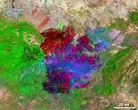
The Landsat series of satellites is used by emergency managers to acquire a range of imagery, from floods to fires. Landsat has recently provided both images of the flooding of the Mississippi River and the fires raging in Arizona.

The Landsat Program is a series of Earth-observing satellite missions jointly managed by NASA and the U.S. Geological Survey. Landsat satellites have been consistently gathering data about our planet since 1972.

They continue to improve and expand this unparalleled record of Earth's changing landscapes, for the benefit of all. The next Landsat satellite is scheduled to launch in December 2012.


Related Links
NASA Earth Observatory
Earth Observation News - Suppiliers, Technology and Application

.
Get Our Free Newsletters Via Email
...
Buy Advertising Editorial Enquiries


. Comment on this article via your Facebook, Yahoo, AOL, Hotmail login.

Share this article via these popular social media networks
del.icio.usdel.icio.us DiggDigg RedditReddit GoogleGoogle


EARTH OBSERVATION
Landsat 5 Satellite Helps Emergency Managers Fight Largest Fire in Arizona History
Washington DC (SPX) Jun 20, 2011
The largest fire in the history of the state of Arizona continues to burn and emergency managers and responders are using satellite data from a variety of instruments to plan their firefighting containment strategies and mitigation efforts once the fires are out. The Landsat 5 satellite captured images of the Wallow North and Horseshoe 2 fires burning in eastern Arizona on June 15, 2011 at ... read more


EARTH OBSERVATION
Raytheon to Provide Airborne Processing for Missile Defense Application

Romania summons Iran diplomat over missile shield comment

Israel launches major home front defence drill

NATO chief says missiles will not target Russia

EARTH OBSERVATION
Iran 'speeds up missile development'

India tests nuclear-capable missile

MBDA Qualifies the New Naval Version of the Marte MK2 Missile

JAGM Tri-Mode Seeker Demonstrated Against Moving Sea Targets

EARTH OBSERVATION
Helicopter lost over Libya is new US drone: officials

Thales completes flight demo for automatic landing of rotary wing UAVs

France and Britain to work on military drone: minister

Successful Flights for Skylark Operated by Dominator Unit

EARTH OBSERVATION
Network Integration Tests Aim to Reduce 'Fog of War'

Raytheon Receives US Navy Contract to Support Satellite Communication System

Firebird Uses Three Eyes and Fourth Sensor Payload

New military radio unveiled

EARTH OBSERVATION
Second Hypersonic Flight Ends Prematurely, Brings New Flight Test Data

IAI to Unveil its new advanced Medium-weight Laser Guided Bomb

Heavy Metal Vehicles Roll Out for Soldiers Clearing Combat Environments

Elisra to Supply Personal Search and Rescue Locator Beacons to French MoD

EARTH OBSERVATION
Senate confirms Panetta to head Pentagon

US, Japan delay Okinawa plan but hold firm

Lockheed Martin Launches New F-35 Website

Zodiac Wins New Contract for 20 Commando RIBs and 4 Air Delivery Systems

EARTH OBSERVATION
Ukraine secretly ramps up ties with NATO: report

Ban gets new term in 'the most impossible job on Earth'

China seeks better military ties with India

India military delegation arrives in China

EARTH OBSERVATION
Raytheon Acquires Directed Energy Capabilities of Ktech Corporation

MLD Test Moves Navy A Step Closer To Lasers For Ship Self-Defense

US Navy And Northrop Grumman Accomplish Goals For At-Sea Demonstration Of Maritime Laser


Memory Foam Mattress Review
Newsletters :: SpaceDaily Express :: SpaceWar Express :: TerraDaily Express :: Energy Daily
XML Feeds :: Space News :: Earth News :: War News :: Solar Energy News
.

The content herein, unless otherwise known to be public domain, are Copyright 1995-2011 - Space Media Network. AFP and UPI Wire Stories are copyright Agence France-Presse and United Press International. ESA Portal Reports are copyright European Space Agency. All NASA sourced material is public domain. Additional copyrights may apply in whole or part to other bona fide parties. Advertising does not imply endorsement,agreement or approval of any opinions, statements or information provided by Space Media Network on any Web page published or hosted by Space Media Network. Privacy Statement