| . |  |
. |
Boston MA (SPX) Mar 30, 2011 A new NASA-funded study has revealed widespread reductions in the greenness of the forests in the vast Amazon basin in South America caused by the record-breaking drought of 2010. "The greenness levels of Amazonian vegetation - a measure of its health - decreased dramatically over an area more than three and one-half times the size of Texas and did not recover to normal levels, even after the drought ended in late October 2010," said Liang Xu, the study's lead author from Boston University. The drought sensitivity of Amazon rainforests is a subject of intense study. Scientists are concerned because computer models predict that in a changing climate with warmer temperatures and altered rainfall patterns the ensuing moisture stress could cause some of the rainforests to be replaced by grasslands or woody savannas. This would cause the carbon stored in the rotting wood to be released into the atmosphere, which could accelerate global warming. The United Nations' Intergovernmental Panel on Climate Change (IPCC) has warned that similar droughts could be more frequent in the Amazon region in the future. The comprehensive study was prepared by an international team of scientists using more than a decade's worth of satellite data from NASA's Moderate Resolution Imaging Spectroradiometer (MODIS) and Tropical Rainfall Measuring Mission (TRMM). Analysis of these data produced detailed maps showing vegetation greenness declines from the 2010 drought. The study has been accepted for publication in Geophysical Research Letters, a journal of the American Geophysical Union. The authors first developed maps of drought-affected areas using thresholds of below-average rainfall as a guide. Next they identified affected vegetation using two different greenness indices as surrogates for green leaf area and physiological functioning. The maps show the 2010 drought reduced the greenness of approximately 965,000 square miles of vegetation in the Amazon - more than four times the area affected by the last severe drought in 2005. "The MODIS vegetation greenness data suggest a more widespread, severe and long-lasting impact to Amazonian vegetation than what can be inferred based solely on rainfall data," said Arindam Samanta, a co-lead author from Atmospheric and Environmental Research Inc. in Lexington, Mass. The severity of the 2010 drought was also seen in records of water levels in rivers across the Amazon basin. Water levels started to fall in August 2010, reaching record low levels in late October. Water levels only began to rise with the arrival of rains later that winter. "Last year was the driest year on record based on 109 years of Rio Negro water level data at the Manaus harbor. For comparison, the lowest level during the so-called once-in-a-century drought in 2005, was only eighth lowest," said Marcos Costa, coauthor from the Federal University in Vicosa, Brazil. As anecdotal reports of a severe drought began to appear in the news media during the summer of 2010, the authors started near real-time processing of massive amounts of satellite data. They used a new capability, the NASA Earth Exchange (NEX), built for the NASA Advanced Supercomputer facility at the agency's Ames Research Center in Moffett Field, Calif. NEX is a collaborative supercomputing environment that brings together data, models and computing resources. With NEX, the study's authors quickly obtained a large-scale view of the impact of the drought on the Amazon forests and were able to complete the analysis by January 2011. Similar reports about the impact of the 2005 drought were published about two years after the fact. "Timely monitoring of our planet's vegetation with satellites is critical, and with NEX it can be done efficiently to deliver near-real time information, as this study demonstrates," said study coauthor Ramakrishna Nemani, a research scientist at Ames. An article about the NEX project appears in this week's issue of Eos, the weekly newspaper of the American Geophysical Union.
Share This Article With Planet Earth
Related Links More information about this study and the NEX project Earth Observation News - Suppiliers, Technology and Application
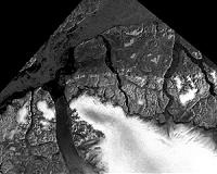 Measurements Of Winter Arctic Sea Ice Shows Continuing Ice Loss
Boulder CO (SPX) Mar 25, 2011 The 2011 Arctic sea ice extent maximum that marks the beginning of the melt season appears to be tied for the lowest ever measured by satellites, say scientists at the University of Colorado Boulder's National Snow and Ice Data Center. The CU-Boulder research team believes the lowest annual maximum ice extent of 5,650,000 square miles occurred on March 7. The maximum ice extent was 463,000 ... read more |
|
| The content herein, unless otherwise known to be public domain, are Copyright 1995-2010 - SpaceDaily. AFP and UPI Wire Stories are copyright Agence France-Presse and United Press International. ESA Portal Reports are copyright European Space Agency. All NASA sourced material is public domain. Additional copyrights may apply in whole or part to other bona fide parties. Advertising does not imply endorsement,agreement or approval of any opinions, statements or information provided by SpaceDaily on any Web page published or hosted by SpaceDaily. Privacy Statement |


 del.icio.us
 Digg
Digg Reddit
 YahooMyWeb
 Google