| . |  |
. |
Washington DC (SPX) Apr 04, 2011 When a crisis occurs on the scale of the earthquake and tsunami that devastated Japan, we all want to help. We thought you might like to know that GeoEye has been supporting the relief efforts by providing its satellite imagery of the devastation in northern Japan to relief agencies, governments and the media.
GeoEye's top priority: Delivering precise satellite imagery to relief agencies, governments and the media By sheer coincidence, the first international license for EyeQ was in Japan, and our partner there, Japan Space Imaging, is using EyeQ to help with the massive disaster relief effort. On March 11, 2011, GeoEye's order management team began directing our high-resolution satellites to collect color imagery over the Oshika Peninsula. IKONOS captured the first post-earthquake image at 10:36 a.m. local time. As of March 21, GeoEye had provided 29,000 square kilometers of imagery to Google. We also gave them special permission to load our Japan data into Google Earth Enterprise on the Go on laptops that were provided to first responders traveling from the U.S. to Japan so they could use the data even where they didn't have Internet connectivity.
GeoEye's imagery is the foundation for detecting change Elite search-and-rescue teams that have flown to Japan from around the world to assist in this enormous relief effort are using our imagery to help locate the missing. In addition, our "before-and-after" imagery has given people around the world an instant understanding of the extent of the destruction. We have posted several new before-and-after "slider" images on our Web site, which reveal the extent of the devastation in Japan.
Share This Article With Planet Earth
Related Links GeoEye Earth Observation News - Suppiliers, Technology and Application
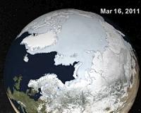 Arctic Ice Gets A Check Up
Grreenbelt MD (SPX) Apr 01, 2011 Scientists tracking the annual maximum extent of Arctic sea ice said that 2011 was among the lowest ice extents measured since satellites began collecting the data in 1979. Using satellites to track Arctic ice and comparing it with data from previous years is one way that scientists track change in the Arctic system. "For the first 20 years of the satellite record, the average annual maxim ... read more |
|
| The content herein, unless otherwise known to be public domain, are Copyright 1995-2010 - SpaceDaily. AFP and UPI Wire Stories are copyright Agence France-Presse and United Press International. ESA Portal Reports are copyright European Space Agency. All NASA sourced material is public domain. Additional copyrights may apply in whole or part to other bona fide parties. Advertising does not imply endorsement,agreement or approval of any opinions, statements or information provided by SpaceDaily on any Web page published or hosted by SpaceDaily. Privacy Statement |


 del.icio.us
 Digg
Digg Reddit
 YahooMyWeb
 Google