| . |  |
. |
Beijing, China (XNA) Apr 02, 2009 China's first two satellites dedicated to environment and disaster monitoring were delivered to their users yesterday. Both Huanjing-1A and Huanjing-1B have two charge coupled device cameras, with a 30-m resolution and a 720-km width, each on board, the State Administration of Science, Technology and Industry for National Defense said in a statement. The Ministry of Civil Affairs, in charge of disaster relief and reduction, and the Ministry of Environmental Protection are the users of the two satellites. They can jointly form the image of China's entire territory in two days, "which not many other satellites with 30-m resolution cameras in the world can achieve", it said. This enables the two satellites to monitor a designated area repeatedly, fast and inform government agencies of the latest disaster development, it said. In February, on the Australian government's request to help fight a rare forest fire, the satellites, then under-testing, provided images, Chen Qiufa, the administration chief, said. Luo Pingfei, vice-minister of civil affairs, said the two satellites would provide a stable, long-term data source to help China fight against disasters. The two satellites will provide data through the soon-to-open Beijing office of the United Nations Platform for Space-based Information for Disaster Management and Emergency Response for global disaster reduction, Chen said. The satellites were launched atop the Long March-2C launch vehicle on Sept 6, 2008, from the Taiyuan Satellite Launch Center in Shanxi province. They passed in-orbit testing in February. Next year China will launch a small radar satellite to work with these two optical satellites, the statement said. Eventually, a total of eight small satellites will be launched to form a constellation for all-weather, 24-hour monitoring and environment and natural disasters forecast, forming a complete image on China once every 12 hours.
Source: Xinhua News Agency Share This Article With Planet Earth
Related Links - Earth Observation News - Suppiliers, Technology and Application
 San Francisco (AFP) March 27, 2009
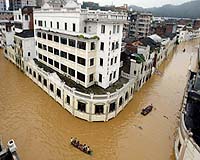
An elected California official wants the state known for Internet technology to blur images of schools, hospitals, government buildings and houses of worship in online maps. |
|
| The content herein, unless otherwise known to be public domain, are Copyright 1995-2007 - SpaceDaily.AFP and UPI Wire Stories are copyright Agence France-Presse and United Press International. ESA Portal Reports are copyright European Space Agency. All NASA sourced material is public domain. Additional copyrights may apply in whole or part to other bona fide parties. Advertising does not imply endorsement,agreement or approval of any opinions, statements or information provided by SpaceDaily on any Web page published or hosted by SpaceDaily. Privacy Statement |
 del.icio.us
 Digg
Digg Reddit
 YahooMyWeb
 Google